Jul 5, 2013

Offline Maps - RMaps and Mobile Altas Creator for abroad traveling


I don't why Google's offline map is so unfriendly. The maps of Japan can not be cached.

Fortunately, the old solution "RMaps and Mobile Altas Creator" is used again. Users can download the solution pack from:  Mobile_Atlas_Creator_1.8_Settings_for_zh-TW.zip (including Official program, SQLite libraries and settings for "Big Planet SQLite" format). 

Followings are heuristic steps for creating offline maps as one sqlite file that can be copy to Android's RMap App. 

1. Create 0-6 levels world map. Thinking you will start for the earth and zoom into your cities, the step avoids missing your starting point due to without map data.

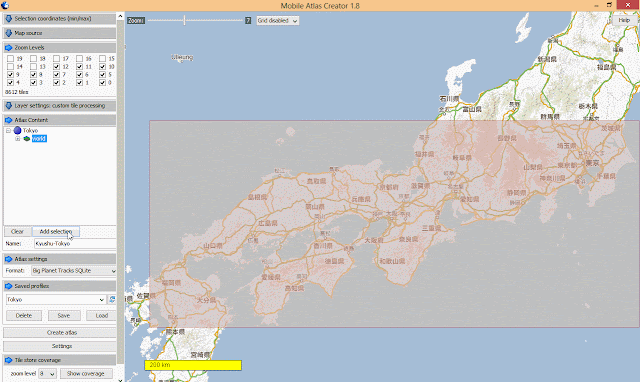
2. "Zoom in" to see the whole path that you'll transport from (e.g. Fukuoka) to (e.g. Tokyo)

3. Select the maximal transportation area so that you can see a coarse grain map while taking JR train for example.

4. Add more level (e.g. 0-12), it depends on the number of tiles.In this example, 8612 tiles are acceptable, no more than such number.


5. Type the submap's name and add selection. 

6. Check the level of tiles is correct as your desired. 

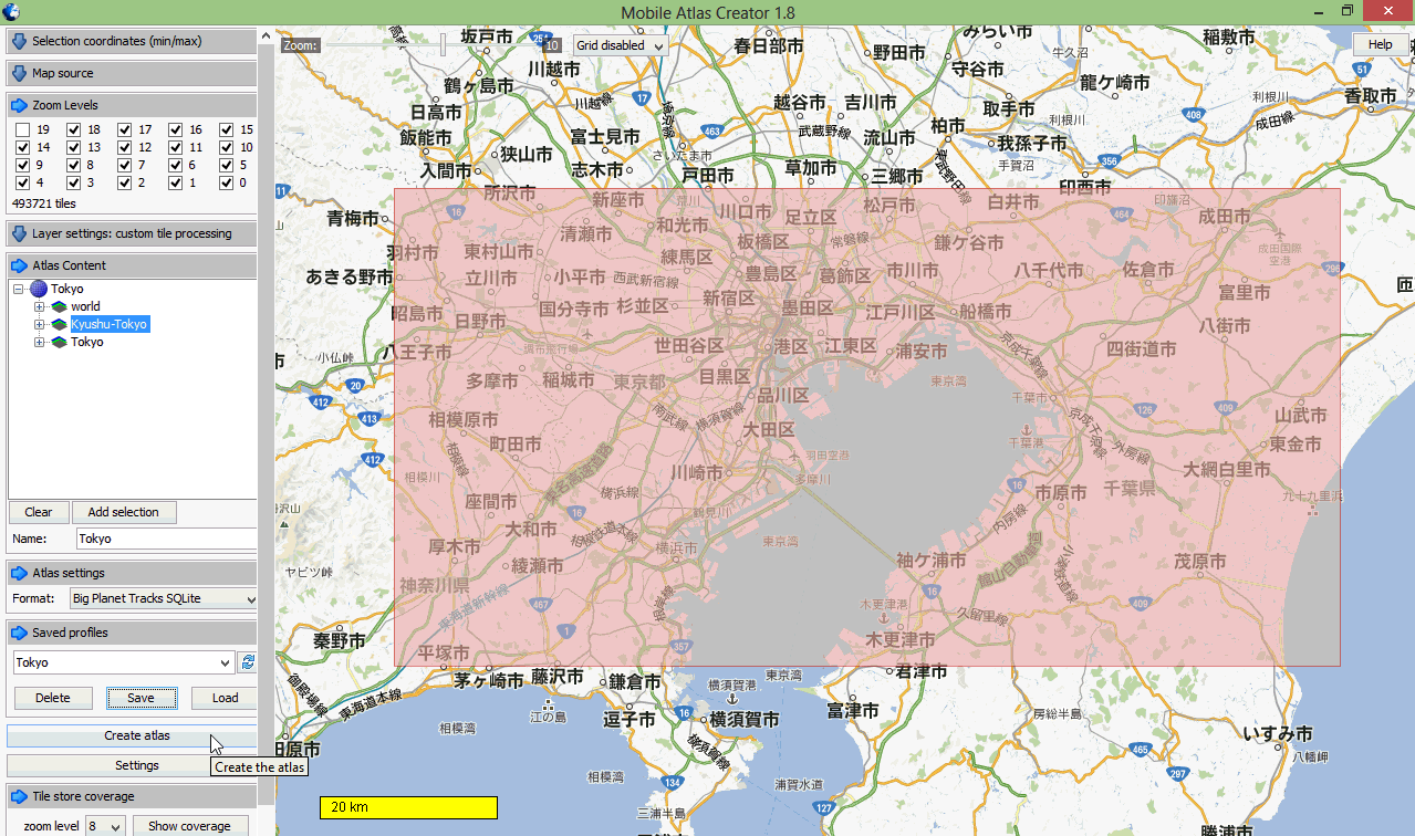
7. The same process is applied to select and add the map of your target city (e.g. Tokyo). Select the maximal city area that you'll visit and set 0-18 levels so that you can clearly see streets and building shapes on the RMap offiine map.

8. Save Profiles so that you can load this setting again for next city without adding "world" and "transportation" maps again.

9. Click "Create altas" then wait a long time for crawling map tiles.

10. Finally, you'll see .sqlitedb file in your FS folder "altases" in your MOBAC directory.

Copying the completed .sqlitedb file to Android's storage (e.g. sdcard1/rmaps/altases), and use your RMaps app by selecting the .sqlitedb map file.

NOTE: Take practice on using RMaps, including:

  • Switch maps from cityA (Fukuoka) to cityB (Tokyo).
  • Input your Google Map locations by downloading as .kml files that can be imported into RMaps as categories.
  • Check you places are covered by RMaps' offline map. If not, don't worry. You don't need a lone time for creating maps again. Just use the "Offline" function of RMaps to cache a small area, it works.


Jun 24, 2013

10,000 Page Views of iLearnBlogger

From 2012/12/18 to now, the total page views of 41 published articles reached the first milestone: 10,000.
Double page views of June in par with last month (May)

The peak day has 281 page views
What kinds of blogs are more attractable, I must study the clue.

How to attract foreign readers outside USA?


Jun 16, 2013

Build a School in the Cloud + Google Project Loon = the Future Education for Rural Areas


之前看了TED演講「Sugata Mitra: Build a School in the Cloud」:

Cover photo
Onstage at TED2013, Sugata Mitra makes his bold TED Prize wish: Help me design the School in the Cloud, a learning lab in India, where children can explore and learn from each other -- using resources and mentoring from the cloud
這時我就就思考到網路與雲端教育連結的問題,Mitra驗證了給窮人機會,他們會自己學習成長。但是如何拉網路或光纖到窮鄉僻壤,光是深山上要申請光世代,hinet都是回覆等等等。直到昨天看了 +Google[X] 的 +Project Loon 終於聯想到兩個創意整合的「未來教育無限可能」,尤其是對於弱勢族群的教育改善。


對於Education on the Cloud的深遠影響,還有 Khan Academy 這是後來由Bill Gates贊助的雲端線上教育服務,已經融入美國多所學校的教育。


Microsoft (Bill Gates) and Google (Sergey Brin) 在致富後,都同樣以其個人資源致力於解決世界難題,值得尊敬。

Google Project Loon:用高空氣球建立全世界的Internet連線


Cover photo


從傳統思維以光纖固網連線,或無線網路連線建立Internet connections,會遭遇許多挑戰:叢林、群島、高山 (土石流一沖刷,光纖可能就跟公路一樣,柔腸寸斷) 或地形崎嶇的區域、網路建置的高成本。因此,許多在非洲、沙漠、貧窮落後國家的人,很難使用到 Internet。在南半球大部分國家的Internet連接費用超過一個月的收入 (In most of the countries in the southern hemisphere, the cost of an Internet connection is more than a month’s income.),很難以想像吧!更難以想像的是,全世界有50-60億人口無法access the Internet。

要如何解決這種困境, 由天真爛漫的Sergey Brin所發起的 Solve for X 計畫,就是要創意整合以解決世界上的難題「Solve for X:Google 聚集全世界最聰明的腦袋解決世界上的難題」。Google正式推出一個大膽有創意的實驗計劃:Project Loon。利用直徑達15公尺的高空氣球把網路基地台帶到比高於20 km的大氣層中 (平流層Stratosphere:7至11km ~ 50km)),這個高度比飛機和雷電風雨產生區域還要高。利用平流層上熱下冷的水平循環特性,可以操控氣球上升/下降,把氣球帶到地球各地,讓氣球平均分散涵蓋地球,從高空中發射網路訊號給陸地的接收和發射器天線 (僅設定於Project Loon所需的訊號頻率,以提高頻寬),建構出「天空之城 天空之網 (network in the sky)」,速度可能比3G網路更快。當然,氣球基地台可以藉由太陽能發電,並且可以受控制,分布於赤道以南的非洲和南美洲區域,以集中涵蓋網路貧乏的區域。

相關研究問題:How to manage a fleet of balloons sailing around the world so that each balloon is in the area you want it right when you need it. 倒是值得資訊學者研究最佳解,最快、最有效省電移動氣球到需要的位置,比如在有大災難發生時。Google已經在Canterbury area of New Zealand徵求50名測試者,連線氣球以蒐集實驗資料。可以追蹤 +Project Loon 瞭解最新發展,這個計畫還有需要全世界人幫忙之處。


影片的結論很感人:Balloon-Powered Internet for Everyone

Project Loon可以加快偏鄉教育的普及進度。


乘著暴風從紐西蘭飛到智利了。


Jun 13, 2013

iOS 7 borrows ideas from Nokia N9 (Meego OS)

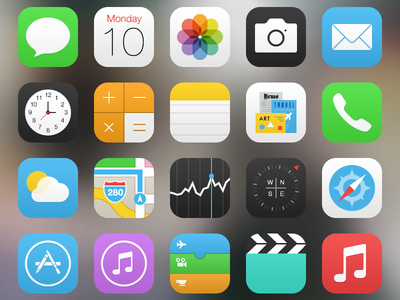
Look icons of iOS 7 (http://dribbble.com/shots/1110960-iOS-7-Icons), the design style is clear-cut and flat.


Remember the UI design of Nokia N9 (Meego OS)? It's very similar.


The idea of swiping from the edge to the center screen is also the same with gestures used in Nokia N9. However, I think only a few developers know what I say.

Also, did you find similarities between Windows Phone 8 and iOS 7?

iOS7 also use Bing Search as the default to reduce the usage of Google services. So will Apple, Microsoft and Nokia become an "implicit" alliance to cope with Google?